“Baby, it’s cold outside…” The winter of 2017 is predicted to bring back a weakened polar vortex, leading to intense and prolonged cold in the northern half of North America. This phenomenon combined with a weakened La Niña will influence the intensity of cold and precipitation expected this winter.
What is the Polar Vortex?
A polar vortex is defined as an area of low pressure in the troposphere. “Vortex” refers to counter-clockwise air flow that keeps colder air at the poles. It is always present and the polar vortex is typically strongest in winter, when the temperature difference between the poles and mid-latitudes are most pronounced. Occasionally, as it did in 2015, the vortex weakens. A weak polar vortex spins slower with more oscillation, allowing colder air to reach areas further south.
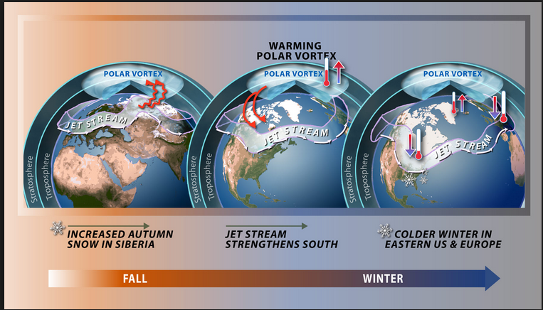
A study in Nature magazine by Dr. Jiankai Zhang and Dr. Wenshou Tian, as well as a study by Dr. Judah Cohen of Atmospheric and Environmental Research (AER) each attribute a weakened polar vortex to increased Eurasian snow cover and decreased Arctic sea ice. Arctic sea ice is at a historic low, which allows more sun warmth to be absorbed by the oceans and then released over a longer period of time, weakening the vortex – and affecting the winter forecast.
Winter Prediction by Region
The U.S. is currently experiencing weak La Niña conditions, with expectations to continue through February 2017. La Niña occurs when ocean surface temperatures in the equatorial Pacific are colder than normal, which disrupts the normal patterns of tropical precipitation and atmospheric circulation.
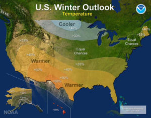
Generally, meteorologists agree that the 2016/17 winter will bring a colder winter with increased precipitation for the northern U.S. – especially in February and March. However warmer than average temperatures and less precipitation are expected for the southern half of the U.S. Therefore there is a greater possibility of the 2014/15 winter being repeated.
New England / Mid-Atlantic: Expect an above-average season for snowfall, together with temperatures 3o – 5o colder than the 2016 winter. Forecasters expect more frequent snowstorms partly fueled by warmer temperatures in the Great Lakes , which favors active “lake effect” snow, especially in the early winter months.
Southeast: Possible freezing temperatures in mid- to late- January, which will cause severe damage to citrus crops. However, a favorable jet stream will keep temperatures slightly above or near-normal.
Upper Midwest: Estimate temperatures 6o to 9o below the 2016 winter due to early snowpack in December. Though artic blasts are forecasted to shorter duration. The possibility of slightly above normal precipitation for parts of the Midwest exists.
Southern Plains / Gulf: Expect a dry winter with no relief for prevailing drought conditions.
Northwest: Above normal precipitation is expected with wet and cool weather in Seattle / Portland and increased snow in the northern Rockies.
Farmers’ Almanac Prediction
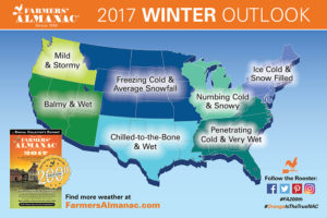
According to the Farmers’ Almanac, December and January will bring mixed winter weather, but February will see severe cold temperatures. Southeast, Northeast and New England regions will see increased precipitation throughout most of the winter, especially February.
While mild temperatures will be felt in the Western States, an active storm track from the Pacific will result in above-normal precipitation. In the middle of the country, the Almanac forecasts near or below-normal precipitation.
…and How Accurate is it?
Predictions are made using a proprietary formula first established in 1818 by David Young, the original editor and forecaster. The formula combines sunspot activity, tidal action of the Moon, position of the planets and other unnamed factors. Today, the formula and forecaster’s identity are secret (pseudonym is Caleb Weatherbee). Generally speaking, the Almanac is said to be 80% accurate but scientists dismiss much of their predictions due to reliance on unconventional indicators and broad brush forecasts.
Ice Dams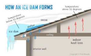
The winter of 2015 saw a rash of ice dam claims, especially in the Northeast where the longest freezing spell was from February 6 to February 21, constituting 16 consecutive days with high temperatures below freezing and average temperatures staying near freezing for the following weeks.
Ice dams occur when ridges of ice form at the edge of a roof and prevent melting snow from draining off the roof. Water then backs up behind the dam and can leak into the home, causing damage to walls, insulation, and ceilings.
Holborn Mapping Analytics
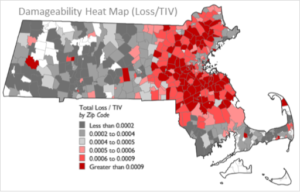
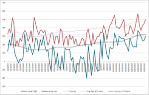
Ice dam events are continuous/progressive losses that start with a snow storm. To support our clients’ efforts to quantify ice dam claims in 2015, Holborn mapped total losses as related to TIV and benchmarked it against the industry. This work helped to identify hot spots where concentration and snow/temperature severity were an issue. Comparing this against reported snowfall charts helped to certify the proximate cause of the loss event. Tracking reported temperatures by affected zip codes against 50 year average high and low temperatures further validated that snowfall from the proximate event did not naturally melt. This established that the ice dams were from the identified proximate event.
With the established loss criteria set, an industry benchmark was created for a series of events. Market share and geographic concentration identified any irregularities in order to investigate individual companies’ reported losses. In conclusion, winter losses and most companies’ industry loss was very similar when accounting for regional concentrations, average claim size, auto, commercial, FAIR plan participation, and IBNR.
Winter Storm Modeling: AIR vs RMS
In addition to post-event analytics, Holborn offers stochastic winter storm modeling. Both AIR and RMS explicitly model event hazards due to high speed wind, ice and snow accumulation, and freeze. Each model uses Numerical Weather Prediction (NWP) models to inform their event sets. NWP models simulate large weather systems in four dimensions, using climate data from sea and air temperatures to water content in the air and air pressure.
Both models simulate weather events in four dimensions. Each storm is modeled in six hour increments across the landscape as well as roughly 14 km into the atmosphere. This is how NWP simulation is done and both vendors preserve this granularity.
AIR utilizes the NWP model results from the National Center for Environmental Prediction (NCEP) and the National Center for Atmospheric Research (NCAR) to identify a subset of individual winter storm events from the NWP data. These events serve as “seed” storms to generate their respective stochastic event catalog.
RMS uses the Community Atmospheric Model (CAM) from NCAR. CAM output is downscaled and biases are removed through statistical modeling of historical winter storm tracks. RMS whittles down these model outputs for run-time purposes, but uses the beta distribution to increase variation within their own event catalog.
These models are relatively new and are still being vetted and evaluated by the industry. Holborn regularly tests
results against client experience.
Holborn Advocacy
As the cold weather unfolds, reach out to Holborn to discuss how our analytics and advocacy can help your exposure management goals.


