

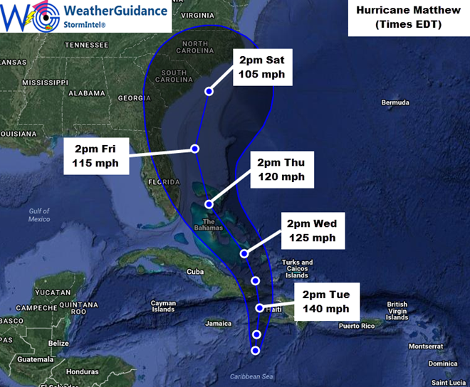
10/3: At 5pm EDT this afternoon the center of Hurricane Matthew was located approximately 140 miles South of Tiburon, Haiti and was moving North at about 7 mph. Maximum sustained winds were near 140 mph with gusts of 150-160 mph. The minimum central pressure was 940 mb/27.76 inches of mercury.
Very damaging hurricane conditions and heavy rainfall will overspread Jamaica and Haiti later tonight into early Tuesday. The center of Hurricane Matthew is forecast to continue moving in a general Northward direction through early Wednesday, then a curve toward the Northwest to North/Northwest is expected from later Wednesday into Thursday and Friday before a recurve back to the Northeast or North/Northeast likely occurs late Friday into Saturday.
…Potential Florida/Georgia Impacts…
At this time, considerable uncertainty remains with respect to the likely track and any potential for direct hurricane impacts on the Florida/Georgia coastlines in association with Matthew. Those with interests in this area should pay close attention to later forecast updates concerning Matthew, particularly for the period Thursday afternoon through Friday evening/Friday night.
The highest winds associated with Matthew are located near and to the East of the center of the system, and this general trend is expected to continue through the end of the week. With this in mind, the center of Matthew would have to track along or inland across the Eastern coast of Florida/southeast Georgia in order for the most significant impacts to be felt with respect to wind and storm surge in those areas. At this time, the center of Matthew is forecast to remain just offshore, which would tend to carry the highest impacts from wind and storm surge just to the East of the peninsula. You may, however, note that the forecast for the track of the center of Matthew has shifted slightly Westward with this update. Future Westward shifts to the forecast are possible, which would potentially result in an increased threat for direct impacts for Eastern portions of Florida and/or southeast Georgia. Please monitor late updates as this situation becomes more clear.
While the potential for direct impacts from Matthew in eastern Florida or southeast Georgia remain in question at this time, indirect impacts in the form of much higher than normal surf, heavy wave action and strong/dangerous rip currents can be expected along the Eastern coast of Florida and southeast Georgia from Thursday through Saturday – even if the center of the system remains offshore.
…Potential Impacts to the Carolinas/Mid-Atlantic…
Beyond Florida and southeast Georgia, a high level of uncertainty exists regarding the likely track of Matthew this weekend, which could include impacts to the Carolinas depending on the motion of the system and the areal coverage of the highest winds by that time. It would be premature to try and estimate potential impacts for the weekend time period for this area at this time, so please monitor for further updates as the situation becomes more clear throughout the week.