

WeatherGuidance Tropical Weather Outlook —
Valid: Today through Thursday (10/3/15-10/8/15)
Current Active Systems – Hurricane Joaquin:
• At 9am EDT, the center of Hurricane Joaquin was located about 480 miles East of Miami, FL. Maximum sustained winds as of the 8am EDT observation were 155 mph and the system is currently moving toward the Northeast at 15 mph.
Outlook and Expected Impacts:

• Joaquin will continue to move out to sea with no direct impacts on the U.S. east coast.
• Very heavy rainfall in excess of 6-10 inches continues to be forecast for much of the mid-Atlantic and southeast this weekend into at least Monday, with the heaviest rain in excess of 12 inches likely in portions of the Carolinas:
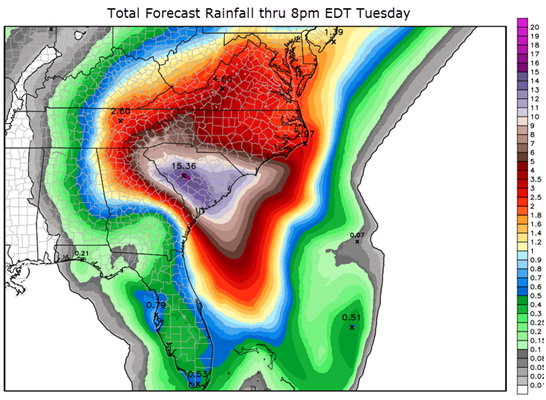
• Excessive rainfall as noted above will lead to an enhanced/significant risk of both flash flooding as well as flooding of rivers and streams across potentially large portions of the area outlined in red on the image below. Please note that historic and/or catastrophic flooding is possible in some parts of this area, especially in parts of the Carolinas (and South Carolina in particular) based on present trends.

Please refer to the Significant Weather Alert regarding heavy rainfall in the southeast for additional details on that hazard.
Discussion:
The center of Joaquin will pass well to the East of the U.S. east coast through mid-week next week. No direct impacts are expected to the U.S. coast as a result of Joaquin, other than increased surf and wave action along the adjacent coastline.
Despite the fact that the center of Joaquin will remain well to the East of the U.S., significant indirect impacts are still likely especially for the U.S. mid-Atlantic region, mainly in the form of heavy rainfall and flooding. Please note the impacts section above for those details.
Other than the indirect impacts from Joaquin as noted above, no other tropical development is expected across the western Atlantic or Gulf of Mexico region through next Thursday that could potentially impact the U.S.
We will continue to monitor this situation very closely and issue updates as conditions warrant.