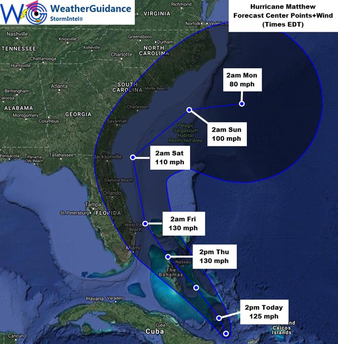
At 9am EDT this morning the center of Hurricane Matthew was located approximately 74 miles North of Moa, Cuba (or about 440 miles Southeast of Miami, FL) and was moving toward the North-Northwest at about 10 mph. Maximum sustained winds were near 115 mph with gusts of 130-140 mph. The minimum central pressure was 964 mb/28.47 inches of mercury.
The center of Hurricane Matthew has started moving in a more North-Northwesterly direction as previously forecast, and will likely turn even more toward the Northwest later today and into tonight/Thursday. On Friday, Matthew is expected to turn more toward a North/Northwest to Northerly direction again, with a turn toward the Northeast expected over the weekend. This Northeast turn may be sharper than earlier forecasts (as indicated on the image above), which has reduced the threat of impacts to the Carolinas and mid-Atlantic over the weekend. A considerable amount of uncertainty exists with regard to the track forecast of Matthew this weekend, so residents and those with concerns in the Carolinas and mid-Atlantic region should continue to monitor for future updates on this system.
…Expected Impacts for Florida…
The highest winds (greater than 80 mph) associated with Matthew continue to be located near/around the center of the system and then to the East of the center of the system. This general trend is expected to continue through the end of the week, with some fluctuations in the wind field at times. At this time, the center of Matthew is still forecast to remain along/near or just to the East of the Eastern coast of Florida on Thursday and Friday. This would tend to confine the highest winds (and also the greatest storm surge risk) along the immediate edge of the coastline in east-central and northeast Florida especially from Thursday night (east-central coast) into Friday (northeast coast).
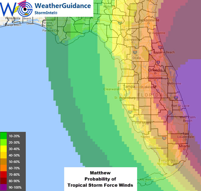
With the above trends in mind, we continue to expect Tropical Storm force winds across especially East-Central Florida from sometime late Thursday evening or Thursday night into Friday. This would especially likely be the case from near West Palm Beach through Daytona Beach. Further inland, tropical storm force winds, especially in the form of gusts, appear likely from the aforementioned coastal points, Westward to possibly as far as the Orlando area. For the inland areas toward Orlando, this would primarily occur from Thursday night through the midday and early afternoon hours on Friday, with a gradual decrease in peak wind gusts through the evening hours on Friday – based on the present forecast track of the system. Please keep in mind that if the system were to slow down with respect to forward motion, then the onset of the winds would be later and they would potentially last longer into the afternoon/evening hours on Friday in this area.
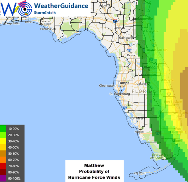
Some concentrated pockets of Hurricane force winds are possible along the immediate coastline especially in east-central Florida, nearest where the center of Matthew is expected to pass just offshore (i.e., especially in the general area from between West Palm Beach and Port Saint Lucie to the Daytona Beach area). Winds will also increase dramatically as you move immediately offshore to the East of these areas.
While all of the above trends have been relatively consistent for the last 24-36 hours, it is very important to keep in mind that any further Westward shifts to the forecast – even a slight one – could potentially result in an increased threat of higher winds further inland across portions of east-central and northeast Florida. Any such Westward shifts would not likely become apparent until during the day on Thursday and/or Thursday evening as the system moves closer to Florida.
Regardless as to the exact track of the center of Matthew, much higher than normal surf, heavy wave action and dangerous rip currents can be expected along the Eastern coast of Florida from Thursday through Saturday. Locally heavy rainfall of 3-6 inches (with locally higher amounts) can also be expected in this region. As with any tropical system, several (generally brief) tornadoes are also possible.
…Potential Impacts to the Carolinas/Mid-Atlantic…
The latest trends suggest that the center of Matthew will remain approximately 75 miles or more to the East/Southeast of the coastlines of the Carolinas over the weekend. If this trend continues, hurricane conditions would remain offshore of the Carolinas, with tropical storm force wins possible along the immediate coastline of both South and North Carolina on Saturday and/or Sunday. We will continue evaluating trends and provide additional details on potential impacts in this area as the situation becomes more clear. Also, at this time, any risk North of the Carolinas appears to be diminishing based on the current expected future track of Matthew late this weekend and early next week.


