

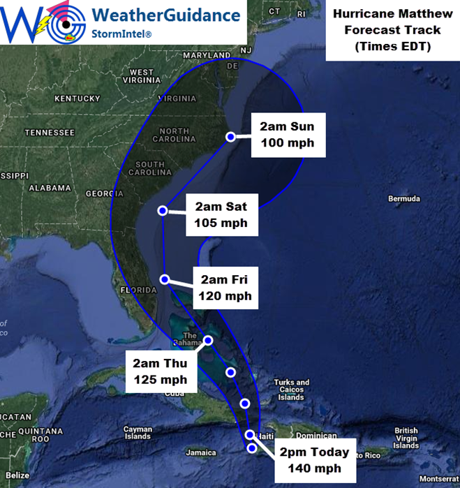
At 9am EDT this morning the center of Hurricane Matthew was located approximately 5 miles Northeast of Tiburon, Haiti and was moving North at about 9 mph. Maximum sustained winds were near 145 mph with gusts of 150-160 mph. The minimum central pressure was 934 mb/27.58 inches of mercury.
Very damaging hurricane conditions and heavy rainfall will continue across Haiti today and will overspread eastern Cuba later tonight and into Wednesday. The center of Hurricane Matthew is forecast to continue moving in a general Northward direction through early Wednesday, then a curve toward the Northwest to North/Northwest is expected from later Wednesday into Thursday and Friday before a recurve back to the Northeast or North/Northeast likely occurs late Friday into Saturday.
…Potential Florida/Georgia Impacts…
At this time, a considerable amount of uncertainty still remains with respect to the likely track and potential for direct hurricane impacts on the Florida/Georgia coastlines in association with Matthew. Those with interests in this area should pay close attention to later forecast updates concerning Matthew, particularly for the period Thursday afternoon through Friday night.
The highest winds (greater than 80 mph) associated with Matthew are located near/around and to the East of the center of the system, and this general trend is expected to continue through the end of the week. With this in mind, the center of Matthew would have to track along or inland across the Eastern coast of Florida/southeast Georgia in order for the highest impacts to be felt with respect to wind and storm surge in those areas. At this time, the center of Matthew is forecast to remain just offshore, with the closest pass expected to be approximately 60 miles East of Melbourne near 2am EDT on Friday morning (based on present forecast trends). This would tend to carry the greatest direct impacts from the highest levels of wind and storm surge along the Eastern edge of the coastline and just to the East of the peninsula. You may, however, note that the forecast for the track of the center of Matthew has again shifted slightly to the West with this update, and any further Westward shifts to the forecast would potentially result in an increased threat of higher winds and storm surge for Eastern portions of Florida and/or southeast Georgia.
At this time, based on the present forecast track of this system, we would expect Tropical Storm force winds across especially East-Central Florida from sometime late Thursday into Friday. This would especially likely be the case from near/North of West Palm Beach through Daytona Beach. Further inland, tropical storm force winds, especially in the form of gusts, appear likely from the aforementioned coastal points, Westward possibly as far as the Orlando area. This would primarily occur from later Thursday evening (likely after Sunset) through the pre-dawn and morning hours on Friday – based on the present forecast track of the system.
Some concentrated pockets of Hurricane force winds are also possible, especially nearest where the center of Matthew is expected to pass just offshore (i.e., in the general area of Melbourne/Palm Bay, as well as the Cocoa Beach and Vero Beach areas, and possibly as far South as the Fort Pierce area.
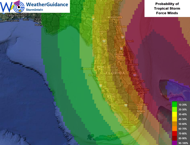
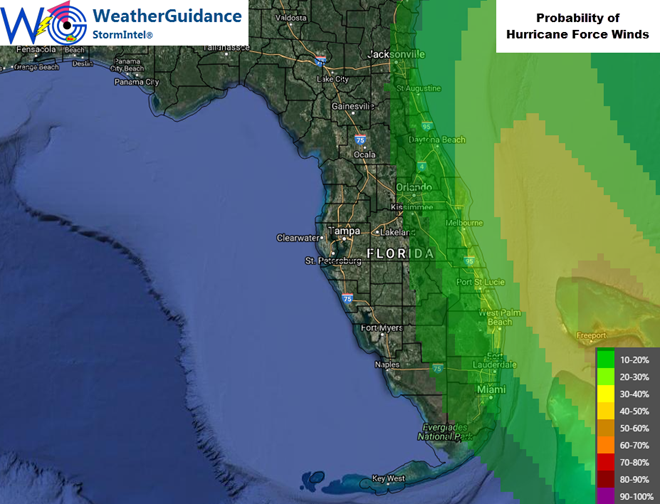
As noted above, any further Westward shift of the center of Matthew would potentially increase the coverage of both the Tropical Storm and Hurricane wind fields – so please stay tuned for later updates as this situation becomes more clear.
Based on the present forecast track of Matthew and the uncertainty that exists with the expected relatively close pass of the center of Matthew to the Eastern coast of Florida, we would expect the government to issue Tropical Storm Warnings and Hurricane Watches and/or Warnings for portions of this area sometime during the day today, valid for the period Thursday afternoon/evening through Friday night.
While the potential extent of direct impacts from Matthew in eastern Florida or southeast Georgia remain somewhat uncertain at this time, indirect impacts in the form of much higher than normal surf, heavy wave action and strong/dangerous rip currents can be expected along the Eastern coast of Florida and southeast Georgia from Thursday through Saturday – even if the center of the system remains offshore.
…Potential Impacts to the Carolinas/Mid-Atlantic…
Beyond Florida and southeast Georgia, an even higher level of uncertainty exists regarding the likely track of Matthew into this weekend, which could include impacts to the Carolinas depending on the motion of the system and the areal coverage of the highest winds by that time. It would still be premature at this time to try and estimate potential impacts for the weekend time period for this area, but these details should become clearer later today and especially on Wednesday. Please monitor for further updates as the situation becomes more clear throughout the week.