

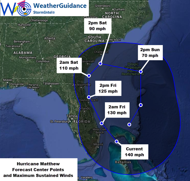
At 5pm EDT this afternoon the center of Hurricane Matthew was located approximately 25 miles to the South/Southeast of Freeport, Grand Bahama Island (or about 100 miles to the East/Southeast of West Palm Beach, FL). Matthew was moving in a general Northwest direction at about 13 mph, with maximum sustained winds near 140 mph. The minimum central pressure was 938 mb/27.70 inches of mercury.
The center of Hurricane Matthew will likely continue to move toward the Northwest through the pre-dawn hours of Friday morning and then turn more toward the North/Northwest to Northerly direction again during the day Friday, passing over or very near the east-central coast of Florida around late morning or midday on Friday. A turn more toward the Northeast is then expected to occur over the weekend. A considerable amount of uncertainty exists with regard to the track forecast of Matthew beyond Florida into this weekend, so residents and those with concerns especially in the Carolinas should continue to monitor for future updates on this system as the situation becomes more clear.
…Expected Impacts for Florida…
The highest winds (greater than 90-100 mph) associated with Matthew continue to be located near/around the center of the system and then to the East of the center of the system. Most computer forecast models continue with this general trend as Matthew approaches Florida, with some fluctuations in the wind field likely at times as the system undergoes cycles of strengthening, weakening and re-strengthening (which is normal for a hurricane of this size and average strength).
At this time, the consensus from computer forecast models, historical and observational data continues to suggest that the center of Matthew will likely track very near the Florida coast later tonight into Friday. Depending on exactly how the track of the center unfolds, it may cross land at Cape Canaveral (or very close) during the late morning or midday hours on Friday. This would tend to confine the highest winds along the immediate coastline of east-central and northeast Florida especially as the system begins its approach later tonight (southeast to east-central coast) and into Friday (east-central to northeast coast).
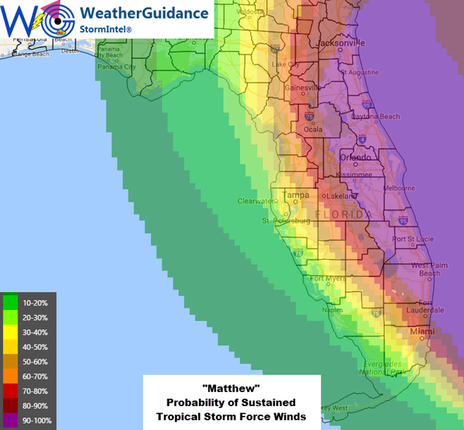
With the above trends in mind, we continue to expect widespread tropical storm force winds across much of the central and Eastern two-thirds of Florida starting later on this evening (South) into Friday (North). The most widespread and strongest occurrence of tropical storm force winds would likely occur from near the Fort Lauderdale/West Palm Beach areas through the Daytona Beach/St Augustine areas. Further inland, tropical storm force winds (both sustained and in the form of gusts) continue to appear likely from the aforementioned coastal points, Westward into the Orlando/Kissimmee areas. For the inland areas toward Orlando, this would primarily occur from the pre-dawn hours on Friday through the early part of the afternoon hours on Friday, with a gradual decrease in peak wind gusts through the late afternoon and evening hours on Friday – based on the present forecast track of the system.
Hurricane force winds are likely along the immediate coastline especially in the Northern part of southeast Florida through east-central Florida, nearest where the center of Matthew is expected to pass overhead or very close by (i.e., especially in the general area from between Fort Lauderdale and West Palm Beach to between Melbourne and Daytona Beach). Depending on the exact track of the center of Matthew and the shape of the wind field at that time, peak winds may exceed 90-100 mph especially along portions of the immediate coastline nearest where the center of the system tracks tonight into Friday (within the general area described in the last sentence above). This will especially be the case if the center of the system actually tracks slightly inland later tonight or Friday morning. If the center remains to the East of the coastline, then this threat will not be as high. It will likely be later tonight before we can tell for sure exactly where the highest coastal winds are likely to occur, as we further evaluate the shape/size of the wind field at that time, as well as the exact track of the center at that time.
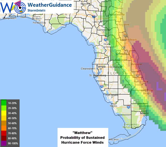
Very important note: While all of the above trends have been relatively consistent for the last 48 hours or so, it is very important to keep in mind that any further Westward shift of the system – even a slight one – could potentially result in an increased threat of higher winds further inland, especially across central, east-central and northeast Florida (including the Orlando area and points from Orlando Eastward toward the coast). We are monitoring for any such Westward shifts and none have occurred thus far, but we will need to continue to monitor for this possibility into the evening and overnight hours as the system continues to move closer to Florida and the precise track of the system as well as the size and shape of the associated wind field becomes more apparent at that time. As a result, while it is certainly prudent to prepare for what is currently expected, it would also be wise to have backup plans in place in case a Westward shift and “worst case scenario” situation were to unfold across portions of central and eastern Florida for the period tonight into Friday.
Storm surge flooding is also expected especially along the east-central and northeast coast of Florida, with inundation levels of 1-3 feet possible especially near the time of high tide. On the image below, the 1ft level is indicated in light blue and the 3ft level is indicated in yellow:
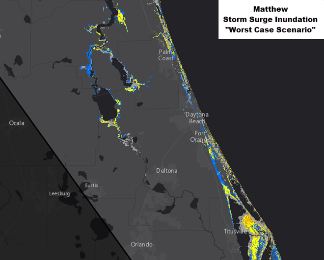
As with other aspects of Matthew, the surge forecast is a bit complicated due to the fact that the system is expected to largely track “parallel” to the coast vs. coming in at a more perpendicular angle. If the system were to turn more toward the West/Northwest and intersect any portion of the coast line at a more perpendicular angle, then the threat of higher storm surge flooding would exist along and to the North of the perpendicular intersection point along the coast.
In addition to the wind and storm surge impacts as described above, much higher than normal surf, heavy wave action and dangerous rip currents can be expected along the Eastern coast of Florida now through Saturday. Locally heavy rainfall of 3-6 inches (with locally higher amounts) can also be expected in this region. As with any tropical system, several (generally brief) tornadoes are also possible.
…Potential Impacts to the Carolinas/Mid-Atlantic…
The latest trends continue to suggest that the center of Matthew will likely remain offshore to the South and Southeast of the coastlines of the Carolinas over the weekend. If this trend continues, the bulk of the hurricane wind conditions would most likely remain just offshore of the Carolinas, with tropical storm force winds possible along the coastline and far Southern portions of both South and North Carolina on Saturday and/or Sunday. We will continue evaluating trends and provide additional details on potential impacts in this area once the system moves past Florida and we can better gauge its intensity and track at that time.
Any hurricane/tropical storm risk to the North of the Carolinas continues to appear low, as it appears the system will recurve back to the East (or even possibly back to the Southeast) later this weekend and into early next week, but again, much uncertainty exists with respect to the later period forecast, so please stay tuned for further details to be forthcoming.