
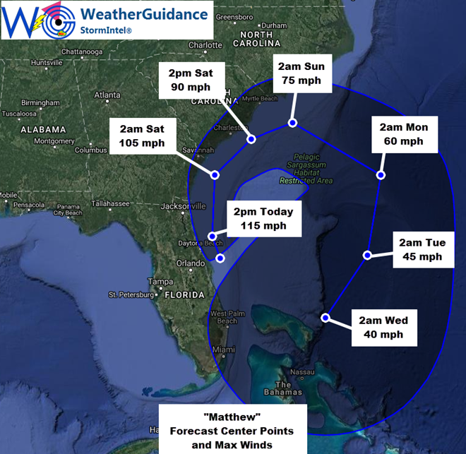
At 8:30 am EDT this morning the center of Hurricane Matthew was located approximately 22 miles to the North/Northeast of Cape Canaveral, FL). Matthew was moving in a general North/Northwest direction at near 15 mph, with maximum sustained winds near 120 mph (mainly to the East of the center over water) . The minimum central pressure was 944 mb/27.86 inches of mercury.
The center of Hurricane Matthew will likely continue to move toward the North/Northwest, generally to the immediate East of the Florida coast today. The highest winds (in excess of 90 mph) will likely remain offshore along and to the East of the center of the system, based on the the current track.
…Expected Impacts for Florida Today…
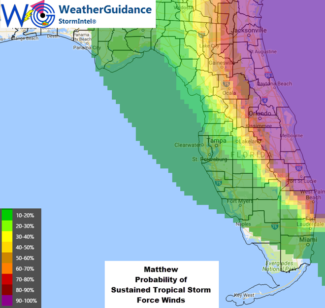
Widespread tropical storm force winds (sustained and/or gusts) will continue across much of east-central and northeastern Florida today. The most widespread and strongest occurrence of tropical storm force winds will likely occur from near Port Saint Lucie (early) through Jacksonville (late morning into much of the afternoon). Further inland, tropical storm force winds (both sustained and in the form of gusts) will continue from the aforementioned coastal points, Westward into the Orlando/Kissimmee areas. For the inland areas toward Orlando, this would primarily occur through the midday hours today, with most winds near 40 mph sustained with frequent gusts in the 45-50 mph range this morning and midday. A few brief gusts just over 50 mph are possible mainly this morning.
With the center of Matthew likely to remain immediately offshore most of the day today, hurricane force winds are most likely along the immediate coastline from near Cape Canaveral to between Palm Coast and Jacksonville (but not likely in the Jacksonville area itself).
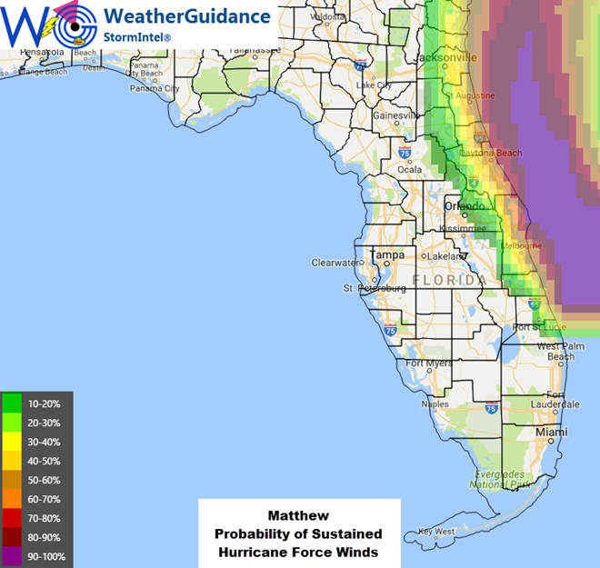
Even within the aforementioned area along the immediate coastline, most of the winds today will likely be of Tropical Storm Force, with mainly gusts in the Hurricane Force range. If the center were to wobble closer to the coastline in any part of this area, then hurricane force sustained winds would be possible accordingly.
Storm surge flooding will continue especially along the east-central and northeast coast of Florida today, with inundation levels of 1-3 feet possible especially near the time of high tide. On the image below, the 1ft level is indicated in light blue and the 3ft level is indicated in yellow. Isolated areas of 3-6 foot storm surge are possible within the orange shaded areas on the same image:
As with other aspects of Matthew, the surge forecast is a bit complicated due to the fact that the system is expected to continue and largely track “parallel” to the coast vs. coming in at a more perpendicular angle.
In addition to the wind and storm surge impacts as described above, much higher than normal surf, heavy wave action and dangerous rip currents can be expected along most all of the Eastern coast of Florida through Saturday. Locally heavy rainfall of 3-6 inches (with locally higher amounts) can also be expected in this region. As with any tropical system, several (generally brief) tornadoes are also possible.
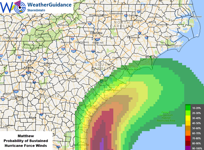
…Expected Impacts for Georgia and the Carolinas Later Today into This Weekend…
The center of Matthew is likely to remain over water to the East of Georgia later today into tonight, and to the South of the Carolinas over the weekend. This track will continue to keep the highest winds and wind related impacts offshore away from land, with mainly Tropical Storm force winds inland:
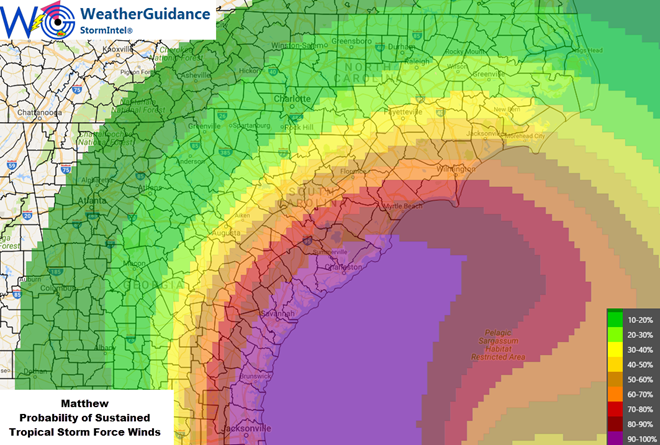
The primary risk for hurricane force winds in the Georgia/Carolinas region will be in the form of gusts, and especially along the immediate shoreline in Georgia later today or tonight and in South Carolina late tonight into Saturday:
Due to the angle of arrival and forecast movement of Matthew, storm surge flooding will mainly 1-3 foot levels as shown in light blue below, and some 3-6 foot levels possible as shown in yellow. The primary risk of storm surge flooding in these areas will be near the time of high tide in Georgia today/tonight and in the Carolinas over the weekend:
Locally heavy rainfall of 3-6 inches is likely with localized higher amounts possible in the southeast Georgia/Carolinas region in association with Matthew. Isolated tornadoes are also possible, but are not likely to be numerous due to the angle of approach and forecast track of the system.
…Outlook Beyond This Weekend…
Matthew is forecast to turn back toward the East and then South into early next week, meandering over the area generally to the East of Florida and to the North of the Bahamas through mid-week, likely as a weak tropical storm by that time. There are no additional land impacts expected through Wednesday at this time. Higher than normal surf and wave action can be expected again along the Eastern coast of Florida especially on Tuesday and Wednesday as the system recurves.