
WeatherGuidance Significant Event Update —

A devastating flood situation continues to unfold across portions of the Mid-Atlantic states this morning, centered on the Carolinas. The above image shows total rainfall (based on radar and ground reports) since Friday and is centered on the hardest hit area – the Carolinas region. As you can see, in excess of 20 inches of rain have fallen across portions of central and southeast South Carolina, with the area from Charleston to near Columbia being particularly hard hit.
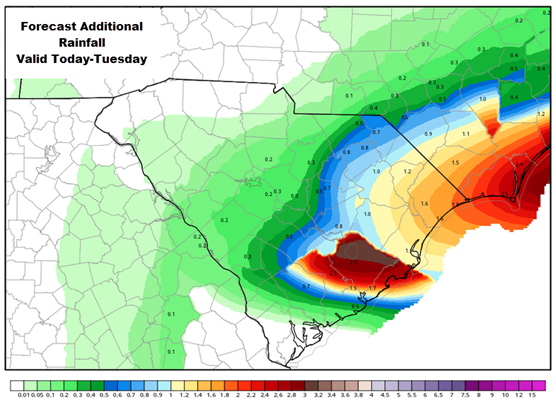
While the heaviest rainfall today and Tuesday is likely to occur just offshore of this region, the potential still exists for an additional 1-2 inches of rain through Tuesday across primarily the eastern one-third of South Carolina and coastal North Carolina, as noted in the image below:
Any additional rainfall today or tonight will obviously further aggravate the already catastrophic to near catastrophic flooding situation that is already underway across much of this region.
Although the heaviest of any additional rainfall will shift to the East and/or decrease across most of the area today into tonight, flooding of rivers and streams will continue – if not increase – across the area through much of this week as the heavy rains of this past weekend continue to run off and cause rivers to keep rising.
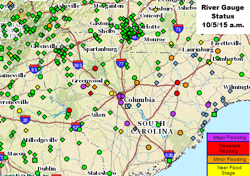
As of 9am EDT today, there were 9 river gauges indicating major flooding, 10 indicating moderate flooding, and 24 indicating minor flooding across the Mid-Atlantic region, with over 40 more gauges indicating levels near flood stage (and rising). Most all of these rivers are still rising and many may not crest until mid to late week this week, depending on the exact amount of any additional rainfall today and tonight, as well as the magnitude of required water releases from dams across the region over the next few days. The image above is centered on the hardest hit areas of South Carolina and the adjacent border of North Carolina, where many rivers are still rising and will not crest until late this week.
There have been many media references to a “1,000 year flood” across parts of South Carolina over the weekend. While technically that is true, there appears to be a considerable amount of confusion over what that exactly means. A “1,000 year flood” means that, in any given year, there is a 1 in 1,000 chance (i.e., a 0.1% chance) of seeing this type of event at any given location. It does not mean that this type of event only occurs every 1,000 years, nor that it will be another 1,000 years before a similar event occurs again. The main take away should be that this type of event is rare and only comes about as a result of several weather circumstances coming together at the same time in a relatively concentrated geographic area.
We will continue to monitor this situation very closely and issue updates as conditions warrant.