
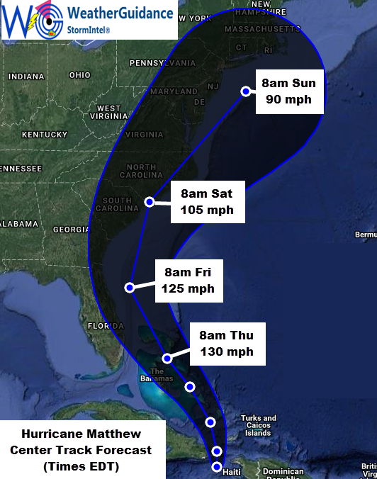
10/4: At 5pm EDT this afternoon the center of Hurricane Matthew was located approximately 50 miles East/Southeast of Guantanamo Bay, Cuba and was moving North at about 10 mph. Maximum sustained winds were near 145 mph with gusts of 155-165 mph. The minimum central pressure was 949 mb/28.02 inches of mercury.
Very damaging hurricane wind conditions and heavy rainfall will gradually end across Haiti this evening and will continue to overspread eastern Cuba through tonight and into early Wednesday. The center of Hurricane Matthew is forecast to continue moving in a general Northward direction through tonight and then curve toward the Northwest to North/Northwest during the day on Wednesday and into Thursday and Friday. A curve back toward the North/Northeast is then expected later Friday and into the weekend.
…Expected Impacts for Florida…
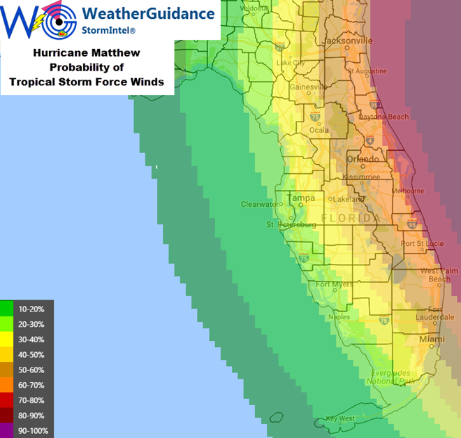
The highest winds (greater than 80 mph) associated with Matthew are located near/around and to the East of the center of the system, and this general trend is expected to continue through the end of the week. At this time, the center of Matthew is still forecast to remain just offshore of Florida, with the closest pass expected to be approximately 40 miles to the East of Melbourne during the pre-dawn hours of Friday morning (based on present forecast trends). This would tend to carry the greatest direct impacts from the highest levels of wind and storm surge along the Eastern edge of the coastline and just to the East of the peninsula. You may, however, note that the forecast for the track of the center of Matthew has again shifted slightly to the West with this update, and any further Westward shifts to the forecast would potentially result in an increased threat of higher winds and storm surge for Eastern portions of Florida.
At this time, based on the present forecast track of this system, we would expect Tropical Storm force winds across especially East-Central Florida from sometime late Thursday evening or Thursday night into Friday. This would especially likely be the case from near/North of West Palm Beach through Daytona Beach. Further inland, tropical storm force winds, especially in the form of gusts, appear likely from the aforementioned coastal points, Westward into the Orlando area. This would primarily occur from late on Thursday evening (likely after Sunset and especially closer to Midnight on Thursday night) through the pre-dawn and morning hours on Friday – based on the present forecast track of the system. If the system were to slow in forward speed, these impacts could extend into the afternoon hours on Friday in this area.
Some concentrated pockets of Hurricane force winds are also possible in east-central Florida, especially nearest where the center of Matthew is expected to pass just offshore (i.e., in the general area of Melbourne/Palm Bay, as well as the Cocoa Beach and Vero Beach areas, and possibly as far South as the Fort Pierce area.
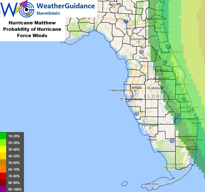
It continues to be very important to note that any further Westward shift of the center of Matthew would potentially increase the coverage of both the Tropical Storm and Hurricane wind fields both along the coast and inland across Florida, so please stay tuned for later updates as this situation becomes more clear. This situation should become even more clear during the day on Wednesday and Wednesday night as the system approaches the peninsula from the South.
Regardless as to the exact track of the center of Matthew, much higher than normal surf, heavy wave action and dangerous rip currents can be expected along the Eastern coast of Florida and eventually into southeastern Georgia from Thursday through Saturday. Locally heavy rainfall of 3-6 inches (with locally higher amounts) can also be expected in this region. As with any tropical system, several (generally brief) tornadoes are also possible.
…Potential Impacts to the Carolinas/Mid-Atlantic…
Based on the present forecast track of Matthew, impacts from tropical storm and/or hurricane force winds and storm surge appear increasingly likely across the Carolinas from late on Friday into Saturday, and then into portions of the mid-Atlantic from later Saturday into Sunday. The exact timing and impacts are still somewhat in question, but these should become more clear on Wednesday and Thursday. Please monitor for later updates as this situation becomes more clear.